Sometimes it happens that your track recording is faulty – it is inaccurate, contains “bumps” or “bounces” or is inappropriately shortened when a part of it is missing. All these bugs are result of Locus Map receiving bad GPS data from your device – mobile phone or tablet. In this article, we’ll discuss reasons of this, how to prevent it and how to fix wrongly recorded tracks.
What is bad GPS data?
We use the term to describe any circumstance where Locus receives location data that does not accurately represent your activity. Bad GPS data can result in your tracks having missing or extra distance recorded or recorded inaccurately, inaccurate elevation values (gain or profile) and more.
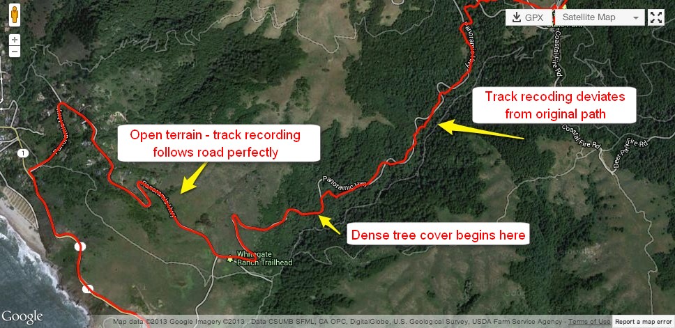
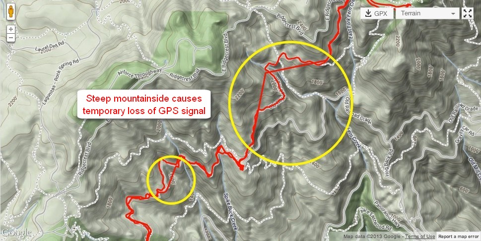
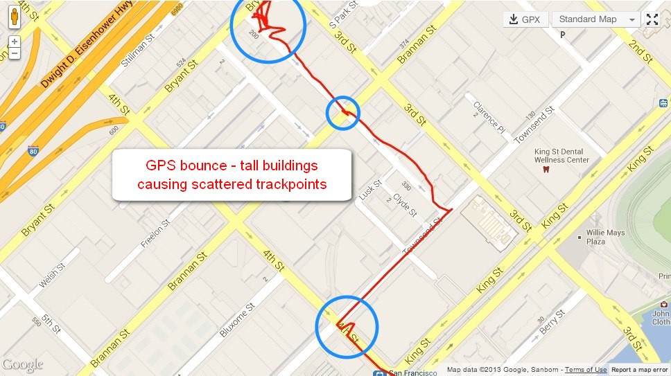
Reasons and effects of this are obvious: your device may have simply lost a connection to GPS satellites and did not record any data – your recorded track shows straight lines ignoring paths or roads on map. Or, your device may have recorded trackpoints that deviate from your true path.
Why does it happen?
Before we mention environmental reasons of receiving bad GPS data it’s necessary to realize that Locus Map runs on personal Android devices equipped with GPS units of which data measuring is far from perfect; in fact, there is some degree of error inherent in any GPS recording. Different devices do simply have different qualities of GPS hardware and software – meaning that even if your device is working at its peak performance, there will always be a margin of error in the accuracy of its recording.
Mobile devices and satellites overhead communicate with extremely fast signals requiring precise detection and any slight inaccuracy in the signal’s reception, or disturbance to the signal itself, can translate to a significant dislocation of your reported position. Therefore, environmental factors such as dense trees, steep hillsides, tall buildings, or even heavy cloud cover can impact or even interrupt the travel of the GPS signal between your device and the satellites.
Can we prevent this?
We can’t advise you to avoid environments that are going to be problematic for a GPS signal – dense forests, canyons, hill sides. That would be against the purpose Locus Map has. However, we can recommend:
- to use a hi-tech device that can communicate with all available positioning networks – GPS, Glonass, Beidou and Galileo. The more satellites visible for your device above your head, the more accurate positioning
- make sure your device is mounted/carried as high up and unobstructed as possible, instead of buried deep in a pocket
- set up your Locus recording profile effectively – GPS accuracy tolerance, time and distance intervals of recording trackpoints. You always have to find a compromise between smoothness and accuracy of the recording. Don’t set up too short intervals (too much data with higher risk of deviations). On the other hand, too long intervals result in a shortened track with approximate progress.
How to fix bad track recording?
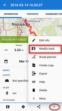
Most of malformed tracks can be repaired in Locus track editor. It can be launched by tapping “Modify track” e.g. in detail screen of the track:
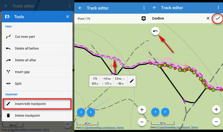
- with track editor, you can fix an inaccurate track – just re-position wrongly located trackpoints:
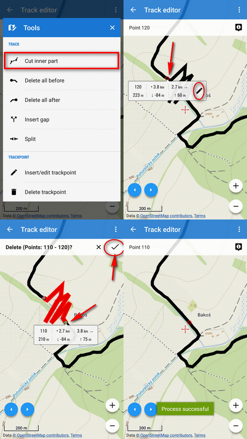
- complex deviations (trackpoint clusters) can be cut out of the track:
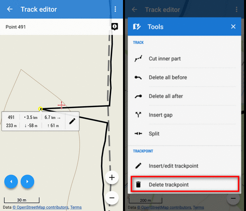
- single GPS bounces consisting of a few or just one deviated trackpoint can be deleted:
Issues with GPS data and accurate location belong to the most often asked at our helpdesk. Hopefully this article can help you understand this topic and give you some advice.
Michal Stupka
Illustrations by author and Strava
bad datadeviationfixGPStrack editortrack recording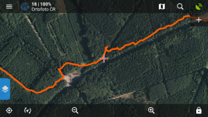

7 Comments
hello, in the last month or so in navigation I lose track, so I have to get out of the navigation and start from the beginning and it happens in mtb (LocusM. Pro) every 100 meters. How can I solve please? do I have to set something?
Hi, this is probably caused by battery optimization of your device that switches off either GPS chip or the app itself. Exclude GPS and Locus from this optimization or turn the optimization off. More info: https://docs.locusmap.eu/doku.php?id=manual:faq:gps_lost_fix_android6
It would be great to implement a filter that would detect very obvious errors. Like, if I set a walking profile and locus gets a position a kilometer away after a few seconds, then after a few second would record a point in a waking range, then the intermediate point could be detected as a mistake and ignored.
Wouldn't be possible to fix part of a track using "routing assistance" feature (the one that Locus uses when drawing routes that snaps them to the map streets and tracks)?
I've proposed it on the help desk here, even though it didn't receive any votes...
https://help.locusmap.eu/topic/recorded-track-cleaning-using-map-matching
You can open the route (track) in route planner and fix it there with "routing assistance"
Eigentlich ist fast alles bestens ei gerichtet. Leider verschwinden in der Kartendarstellung immer wieder Ortsnamen, die ursprünglich angezeigt wurden. Oft sind in der Übersicht Namen nicht zu sehen, die dann bei irgend einem Zoom auftauchen, dafür verschwinden dan andere.
Hi,
we know about this problem and we are solving it. Nevertheless, it is caused by a major failure in the map rendering engine provided by a third party and fixing it is very complicated.