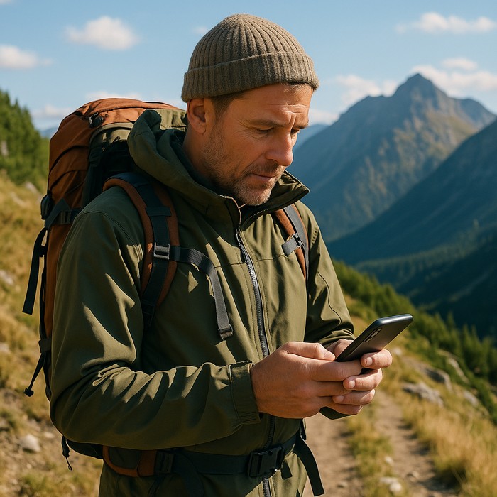
You already know that Locus Map is a versatile and flexible tool that enables a wide range of uses. That it can serve hikers, bikers, geocachers, runners and cross-country skiers is a given. That it can also help rescuers, conservationists, and the development of new technologies we wrote about a year ago.
This is because of the plethora of features and gadgets the app offers. Often these options are somewhat hidden, as you had a chance to see in the article about the “magic” of long pressing some buttons. Today, we’re going to look a little deeper into the menu and bring to light a few features you may not have known about in Locus Map.
Map specialties
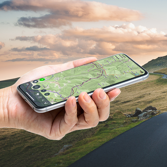
Maps are essential and Locus Map can display a plethora of them – online or offline, of different types, dedicated LoMaps, or maps from various third-party vendors. Now we’ll take a look at a few features that further enrich the map.
Automatic zooming
With autozoom, you don’t have to manually zoom in and out if your hands are on the handlebars or steering wheel – the map zooms itself depending on your current speed. When you’re going fast, the map zooms out, and you can see more of the landscape and get an overview of the overall context and progress along the route. Conversely, when you slow down or stop at an intersection, the map zooms in and you can see all the details you need, such as the shape of the intersection.
Unlike conventional navigation apps, in Locus Map, you can set in detail which zooms to display at which speed. This way you can tailor the auto zoom to any activity, from slow walking to driving, and use the presets to activate it when needed.
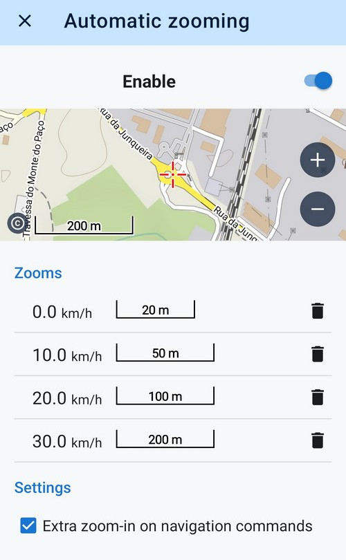
Auto zoom can be found in the map screen settings. Details here >>
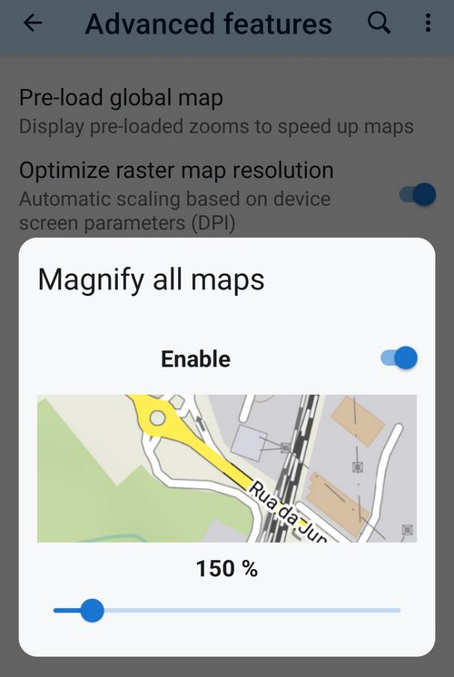
All maps magnification
Many middle-aged people are losing the ability to focus their sight at short distances. For them, Locus Map offers the ability to enlarge all maps from 125% to 800% of the original resolution. You can enable map magnification in the advanced map settings. Details here >>
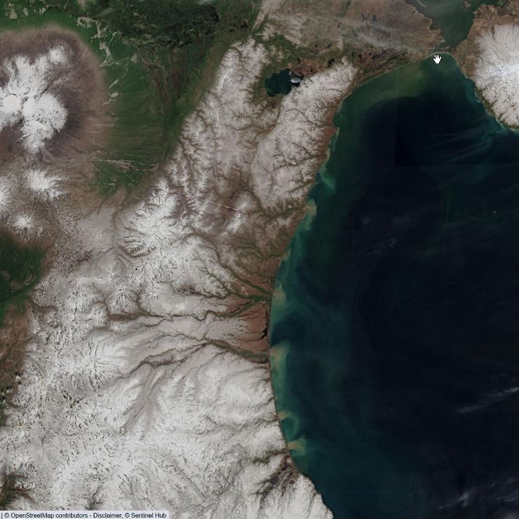
Terrain shading
The classic map shading, which increases the plasticity of the terrain and aids orientation, needs no introduction:
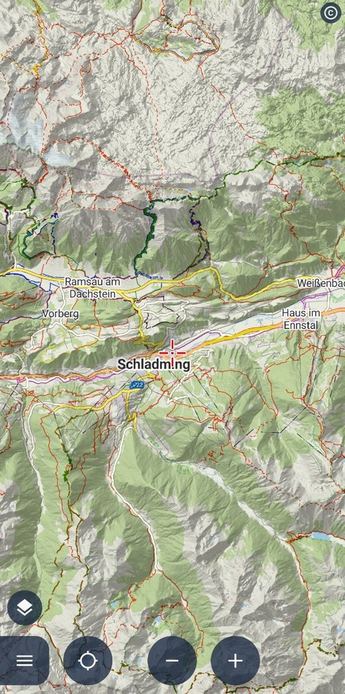
However, Locus Map offers something extra again:
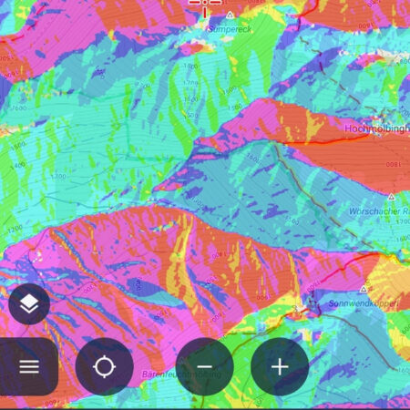
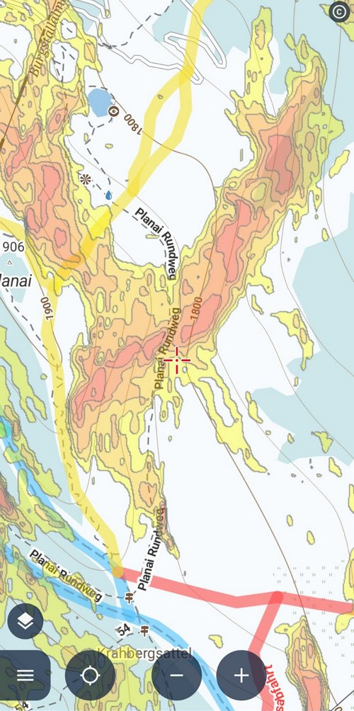
Slope gradients for ski mountaineering
The popular activity on the snow plains of the mountains brings with it one crucial aspect to watch – the slope gradient. The risk of an avalanche increases with a higher angle. Based on elevation data, Locus Map can color-code slopes exceeding 30°, which is critical for safe movement in open terrain. Steeper slopes are further distinguished by a darker color:
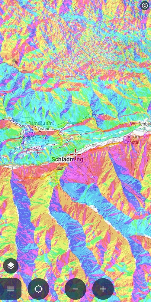
Slope colouring by cardinal directions
Landscape photographers and other hunters of sunrises and sunsets will appreciate being able to tell from a map which slope leans in which direction. The cardinal points are color-coded so you can guess fairly accurately where the shade will be at what time of day:
Quickly turn shading on or off in the map content panel on the left. Details here >>
Auxiliary graphics
The rather generic title in the map settings menu hides some real treasures that can be very useful to you as you wander through the countryside. This section is worth exploring in more detail, but we’ll just list the highlights here:
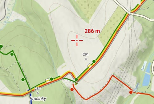
Dynamic elevation
The height of the location on the map is displayed above the cursor. You always know what elevation you are at and the elevation of your surroundings:
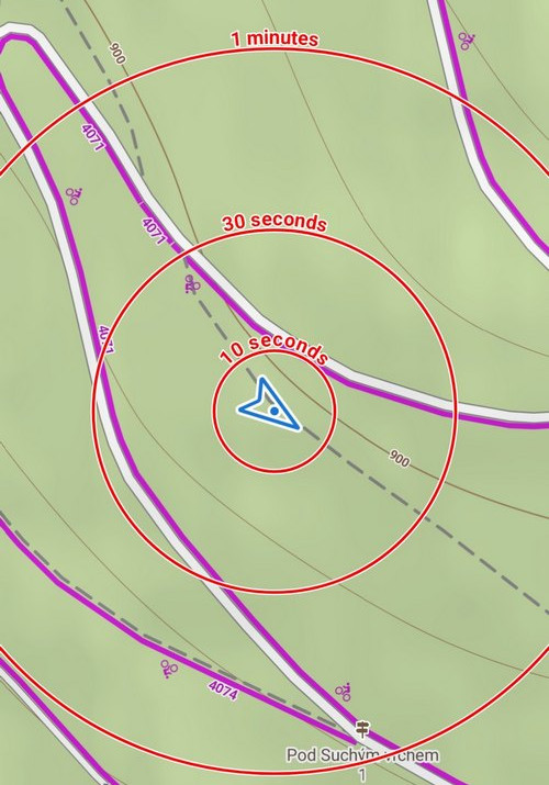
Time circles
Intuitively and quickly show us where we will get to in half a minute, a minute, etc., at the current speed:
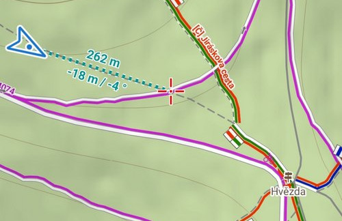
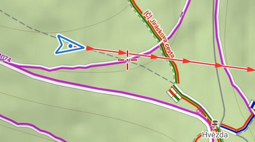
Cursor to position line
A very fast tool to measure the beeline distance between your current location and any other location. You can also add other values to the line such as elevation difference or azimuth:
Course line
This element highlights the direction of your movement. Useful for water sports on a larger body of water:
Heading line
Highlights the direction of rotation of the phone. For example, it can help you find the names of peaks on the horizon or other landscape features you can see from a viewpoint.
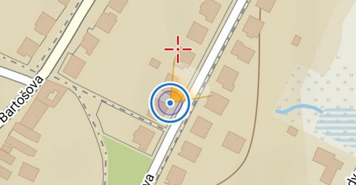
Show view
Particularly helpful for those who have trouble orienting themselves on the map – it shows the viewport you are currently looking at:
More about auxiliary graphics here >>
Specialties for athletes
The primary goal of the Locus Map app is to help people who enjoy being active in the outdoors. In addition to the main functions such as track recording, route planning, navigation, or connection to external sensors, there are also a lot of auxiliary functions that can make these activities even more enjoyable.
Audio coach
The audio coach is appreciated by runners and everyone who needs to know their performance data first-hand, so to speak. When recording an activity (running, cycling or other trail training), Locus Map reports the current statistics of the ongoing activity to the headphones at a selected interval.
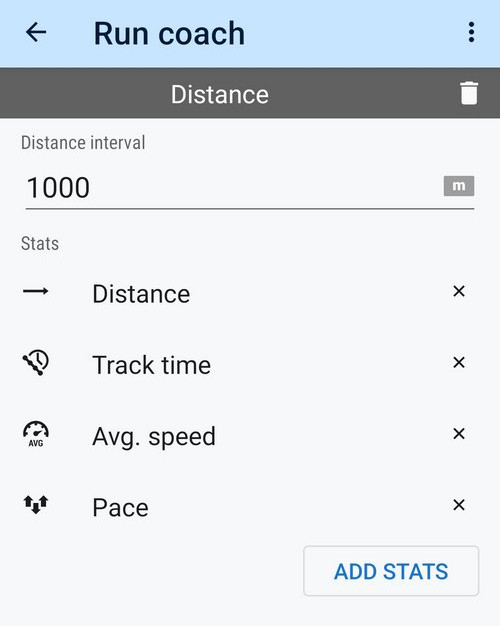
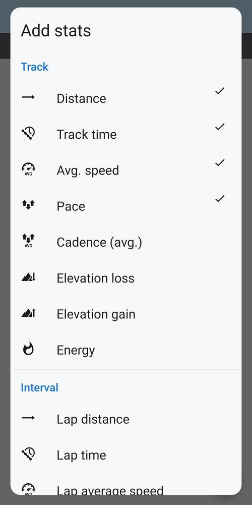
A range of parameters is available – in addition to the usual data such as distance, speed, or pace, Locus Map also provides information on elevation, heart rate, cadence, or energy consumption. The reporting interval can be selected as distance or time, and the parameters can also be layered on top of each other. And don’t worry that you won’t hear your favorite music while running – Locus Map only sounds when it needs to.
You can set up as many audio coaches as you want and use a different one for each sports activity. Connecting audio to a specific route recording profile and starting it automatically is a matter of course.
You can configure the audio coach in the route recording settings. Details here >>
Track naming automation
Locus Map offers several options for naming a recorded track when you save it to your library. The default format is a timestamp, however you can further enrich this or replace it with something else. There is the activity type, start and finish location, country, name of the route you are navigating, start time, and distance traveled.
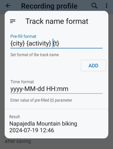
Everything is set using tags in the track recording profile settings. Here are the details >>
And now something for the experts
As if the primary settings in Locus Map weren’t enough, there are other settings that are rather hidden from the general user. We refer to these as “Expert” and they can be used to set up almost anything you can imagine. Just to name a few:
- colors and styles of all possible auxiliary lines above the map and graph curves
- colors and fonts of titles or labels
- detailed settings for hardware drivers
- various tweaks and shortcuts
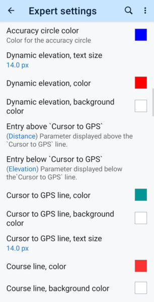
However, there are also settings that may not work properly on all phones, such as fullscreen, as well as a few options for developers, so it’s best not to touch them at all. Either way, you can customize Locus Map in many, many ways.
And how do you activate the expert settings? You can find everything here >>
Locus Map LITE – iOS cherry on top
What does iOS have to do with the unknown features of Locus Map, you ask? The “unknown”. This time, however, not for users, but for us developers – until recently, the iOS platform was an unknown and unexplored place for us.
We admit, throughout the history of Locus Map development, we couldn’t imagine developing an app for another platform. However, as they say, “Never say never”, and so, after less than two years of intensive work, we created our first iOS app – the Locus Map LITE.
Not to be misled – this is not the equivalent of the Android Locus Map. Locus Map LITE is so far just a Locus baby that can only do a fraction of what its “adult” Android brother is capable of. Anyway, we want to teach it as much as possible in the future to make it as much the same as the Android app.
And what can Locus Map LITE do now?
- display your location on an online LoMap or satellite map
- record your activity
- import your route in GPX format
- view your route and waypoint library and synchronize it with the web
You can learn all about it on its brand new page at www.locusmap.app/ios.
24 Comments
Truly one of the most complete/complex map app on Android.
Greetings from Romania Carpathians mountains.
The go-to for bike transit bat survey now going to iOS. What a bliss!!
Ahojte. Výborná práca. Ďakujem
Hallo
Gut, die neuen Funktionen. Für mich ist im alltagliche Navigieren einfach wichtig, das ich die Basisfunktionen gut erreiche und nicht lange Handbücher wälzen muss. Sollte es dann etwas anspruchsvoller werden, bin ich gerne bereit, mich in die Expertenfunktionen einzuarbeiten und hoffe, diese auch sinnvoll nutzen zu können.
Hi, these features are not new, they're just unfamiliar to many. Regarding simplification - you can set the app according to your needs - place your favorite features buttons in the functions panels, customize the map content panel, and the main menu - there are many options. You can even hide the features you don't use so they do not bother you.
La uso ogni volta per andare a fare trekking in montagna su posti che non conosco e tante volte mi ha tirato fuori dai guai nei sentieri che trovo non segnalati.... app precisa indispensabile la migliore....complimenti.
Really great app. However, speaking of terrain, a very good feature would be dynamic elevation colors relative to the current frame, like with The World topographic map
https://en-gb.topographic-map.com/map-4d9jnh/The-World/?center=48.13228%2C8.88579&zoom=6
Hi Philipp, this kind of coloring is available in Locus Map: see "colored elevation" in https://docs.locusmap.app/doku.php?id=manual:user_guide:maps_settings#map_shading
Immer wieder gut, seit Jahren gerne genutzt für Wanderungen, Radfahren und auch mal Autonavigation. Super mit offline Karten möglich. Zur Orientierung, Blickrichtung, was ist das am Horizont usw. Auch Geocaching.
Weiter so, ihr macht das gut.
Aussichten auf ein iPhone in den nächsten Jahren steigen 🤩
Vynikající Česká záležitost, kterou milují lidé, po celém světě! Jen tak dál, skvělá práce!
Gute Erklärungen. Was ich mir seit langem wünsche, ist eine Einfärbung nichteinsehbarer Räume. Alles, was man im Geländeschnitt nicht sieht (durch das Relief) zum Beispiel grau opak Überlagern. Das wäre fein.
Hi Ulrike, specify your request at help.locusmap.eu, section "Ideas" and let other users vote for it. When the idea gets enough support, we may start thinking about implementing it.
I really absolutely love your app but there is one function very useful for navigation, especially with speeds faster than walking, that is not yet incorporated in your app. In the App "All-in-One Offline Maps" in the Google Play Store the function is called Explorer Mode. I still want to send you a feature request email with elaborate explanation and Screen Recordings as a Feature Request for Locus Map but haven't found the time yet.
Hi, we will be looking forward to it. Get in touch anytime at help.locusmap.eu.
The Audio Coach is superb and can even announce my heart rate at frequent intervals for the indoor trainer. Locus Maps is a complete app in every sense. As the default says, I love Locus.
Any chance in android auto compatibility? This would be so awesome!!
Thanks
Android Auto seems to reach alpha state behind the scenes...
Yes, the development is in progress. But many obstacles still ahead...
Plane gerne meine Fahrradrouten über Locus map am Computer.
Die bereits in der Karte angezeigten Radwege werden aber zum Teil von Locus Map völlig ignoriert und er leitet mich an diesen teilweise komplett vorbei. Eingestellt ist Tourenfahrrad.
So ist das Programm leider nicht zu gebrauchen. Schade...
Hi, could you please contact us at https://help.locusmap.eu/ticket/add and send detailed description of the issue including location of the problematic area? Thanks.
Love Locus Map but would like to see coordinates grids (WGS and UTM). Found some chats about grids from years ago but can't find them in the current version (4.25.1). Has this feature been removed or where can it be activated?
Cheers
As I've written on the helpdesk, it can be turned on in the content panel on the left edge of the screen.
Hi, this application is very useful for creating and determining my own map routes, but the use of English in our country is very minimal, therefore I really hope that developers can add Indonesian to this application, considering that Indonesia has the 4th largest population in the world. That's all our input, thank you.
Hi,
Locus Map is translated to other languages by its users in a crowdsourcing project (see more at https://crowdin.com/project/menion/bg#). Indonesian, unfortunately, is translated only in 4% so we can't publish it. If you speak English and you are willing to participate, you'll be welcomed. The best performing translators get rewarded at the end of each year.