
After two months of intensive work, we bring you again the new version of your favorite outdoor navigation – Locus Map 4.24. In addition to a number of minor fixes and improvements, we of course have a few highlights for you. So let’s briefly introduce them:
LoPoints – the most interesting places on the map
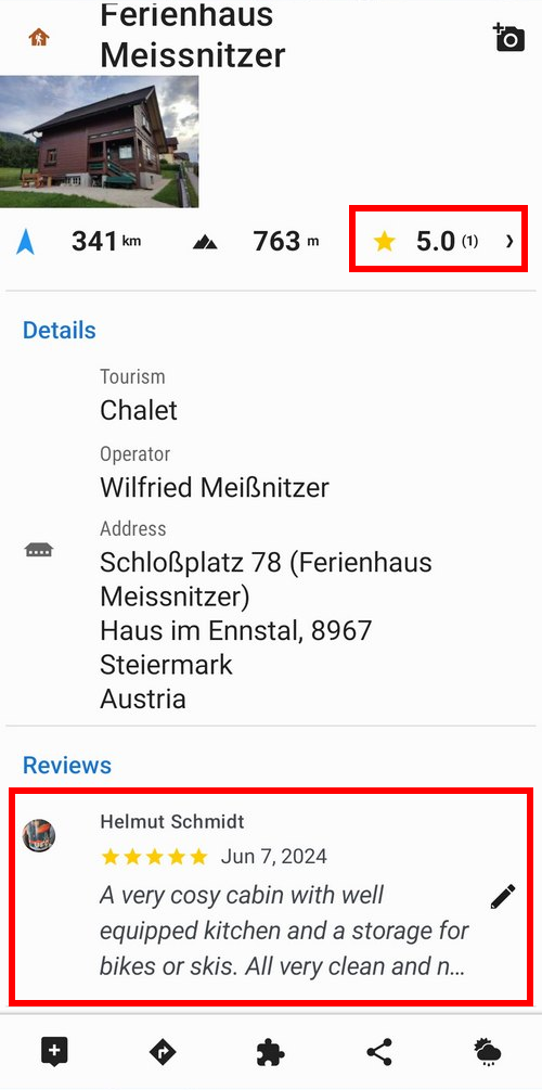
As you know, LoPoints are places on the map marked with icons. They are available online and offline and can be displayed on top of any map. LoPoints are clickable – if you click on them, you’ll see lots of tourist information about the place, often including a description or photos from Wikipedia. Alternatively, there are photos from users who have visited the location and documented its current appearance. You can view the photos both in the app and on the web, including the user gallery. We continue to deepen this user interactivity with map data, as you can see in the following news:
Ratings and comments
You can now add a review to each LoPoint, consisting of a rating and a few words about what you liked or disliked about the place. The rating is similar to Google Play, that is, the highest praise is for 5 stars, the lowest for one star. You can comment on your rating, add recommendations, tips or warnings for others. Of course, all within the framework of civilized and polite attitude.
1 photo for LoPoint = 1 LoCoin to your account
Do you know what LoCoins are? Yes, that’s right, our “virtual currency” with which you can buy maps in the Locus Store, and also purchase Premium features. Until now, LoCoins could only be obtained for money either directly in the Locus Store or on our website. Now, you can also earn them for photos of places you’ve visited.
The ability to add your own photos to LoPoints to document their current status for other members of the community of hikers and outdoor enthusiasts has been around since last year. From now on, we want to give back at least a little bit for your contributing to a good cause:
For every approved photo you attach to LoPoint, we’ll credit your Locus account with 1 LoCoin.
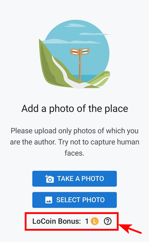
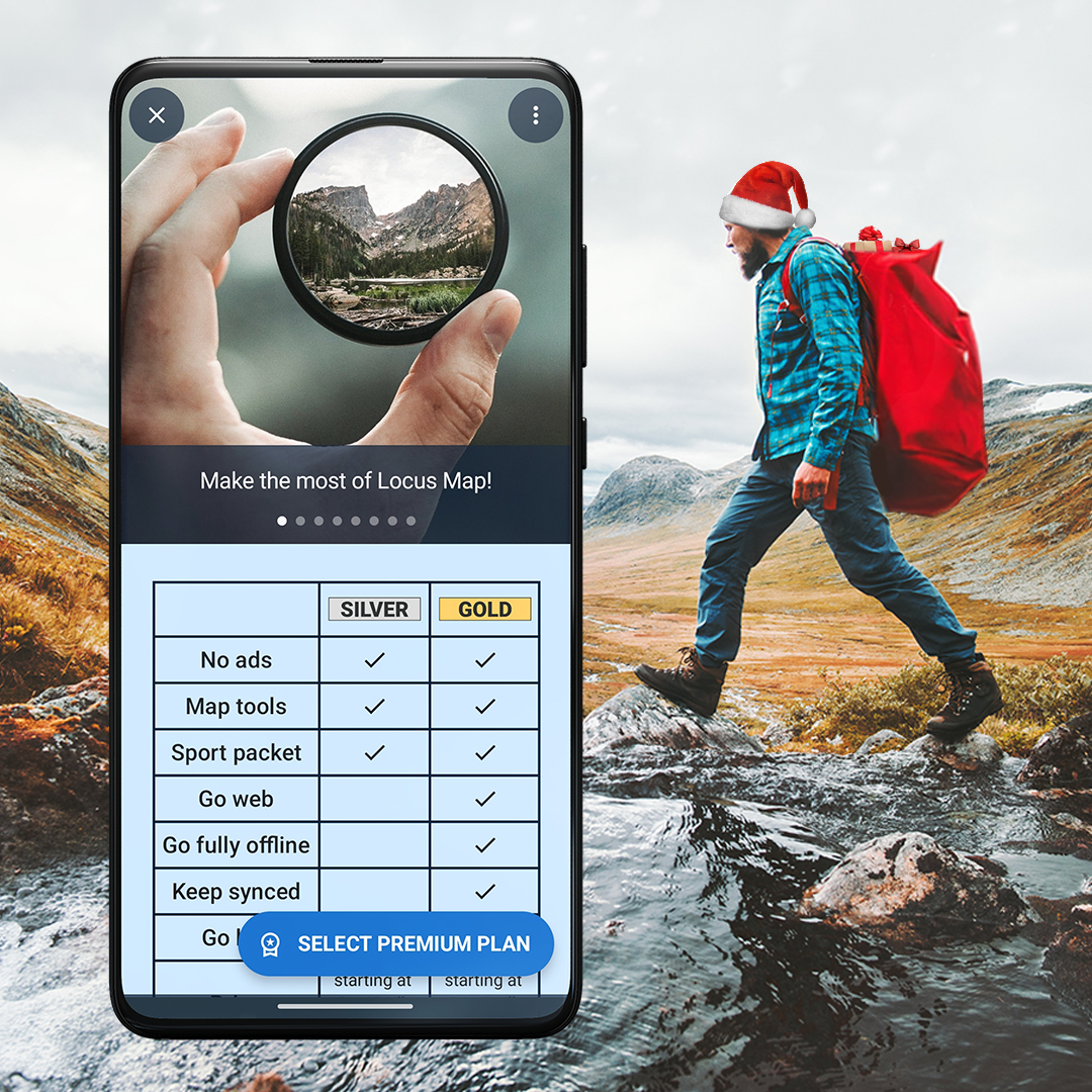
So for 30 photos of interesting paces you can get a LoMap of Croatia, for 225 photos you can get half of Germany, for 869 photos you can get Premium Silver for a year, and if you are creative enough, for 2099 photos you can get Premium Gold for a year! And that’s worth it :).
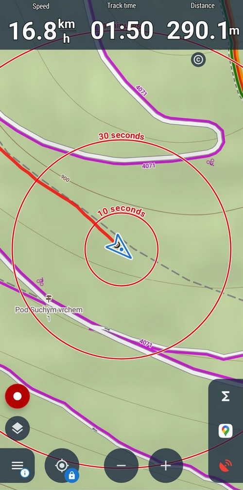
Track recording just got a little bit better
Another topic for modification has become recording the tracks of your trips and training sessions, which we haven’t touched on in a while. We’ve looked into it a bit more and made two major improvements based on your recommendations:
Lower battery consumption
We’ve optimized the recording process, cleaned up elements that were putting unnecessary strain on performance, and the result is significantly lower battery power consumption – you can save tens of percent if you use it all day. Even with the display on.
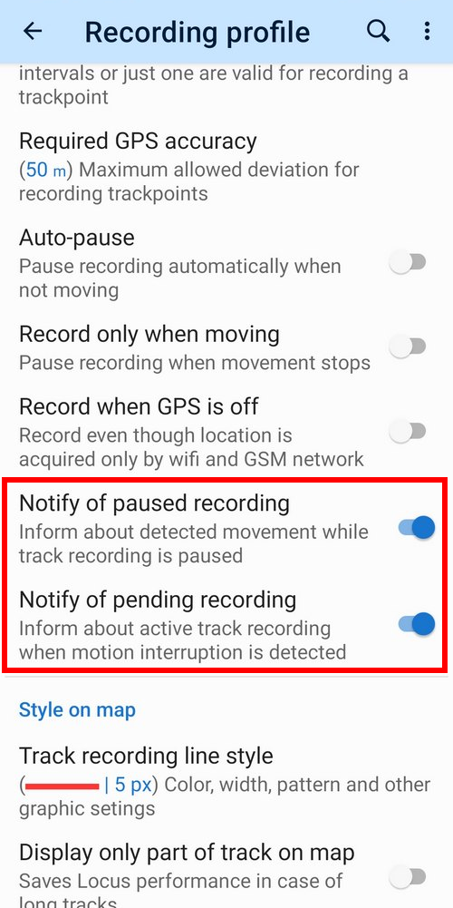
Attention, you are in motion, and you have a paused recording!
Many of you have expressed the wish that it would be good to have a notification in Locus|Map to alert you in the following situations:
- track recording is running, but you have interrupted the activity
- track recording is interrupted but you are moving
And because we’re equipping the app according to your wishes, we’ve added the notifications. You can turn them on or off as needed in the settings of each track recording profile.
Share tracks with photos
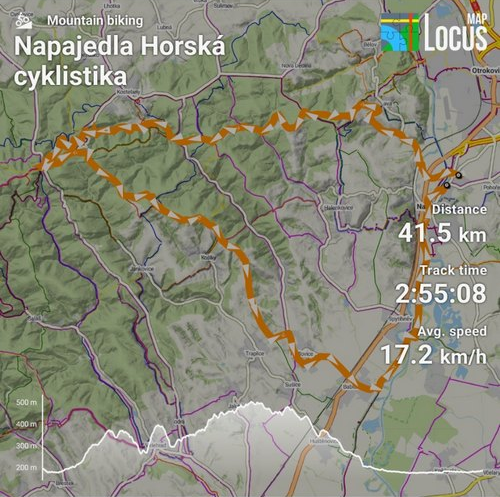
Locus Map is bursting with ways to share your track with friends. With a link to the web, export to GPX, KMZ and other formats like HD JPEG with map and detailed stats… The only thing we were missing was a nice “Instagram” picture to share on your social networks.
So we added it, in three versions. You can share the track with the map in the background:
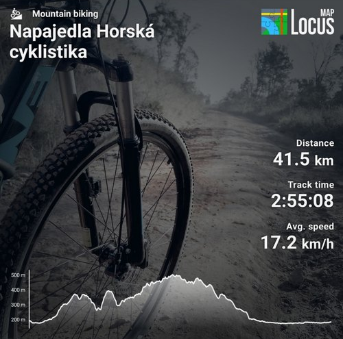
With an image based on the activity on the track:
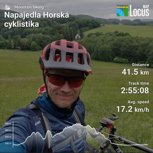
Or with your own picture, taken during the ride:
Plus, something for geocachers and route planners
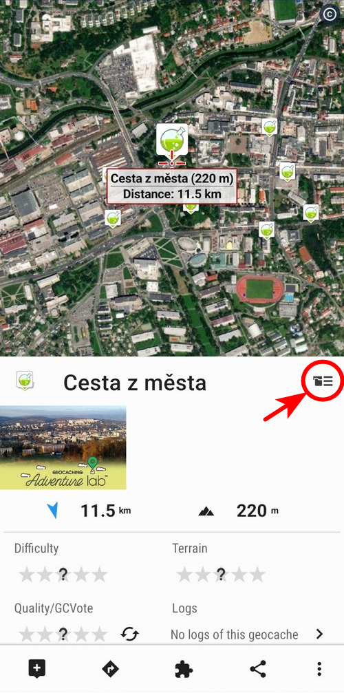
Log labs offline
Passionate geocaching players, specializing in lab caches, will also find something for themselves. We’ve taken Locus’ capabilities up a notch again and added the ability for them to log their catches offline, i.e. without the need to be connected to the internet.
And to save data, you can also set a maximum number of log downloads per cache.
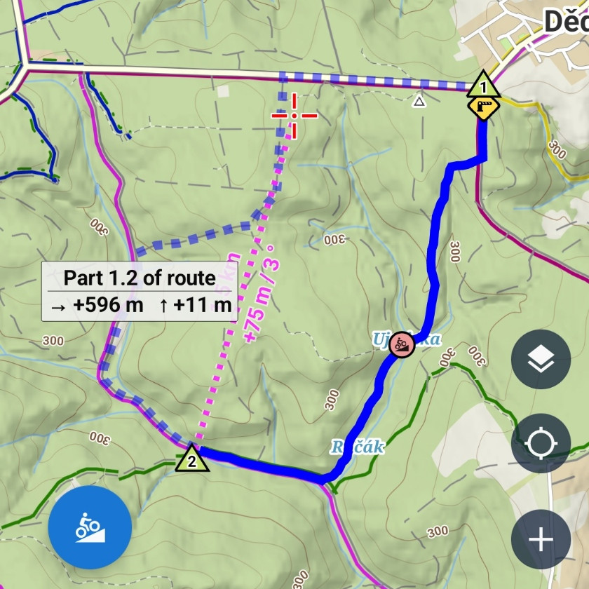
More accurate time estimation on the route
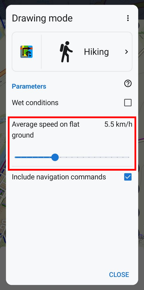
Estimating time on the route is a pretty important factor for many people when planning hiking tours or cycling training trips. So far, time estimation has been very approximate based on general criteria and parameters. Now we introduce the possibility to adjust some factors according to one’s own abilities, which makes the time estimation much more precise.
For the “walking” and “hiking” routing profiles, we have added the ability to adjust the default speed on the flat. This becomes the basis for calculating the time estimate, which incorporates other internal parameters such as elevation, gradient angle, and surface type. These are already taken by the application from routing and elevation data. The default speed can be set between 2 – 12 km/h, so even recreational runners can use it.
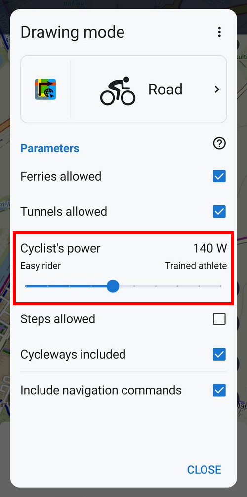
Road cyclists, on the other hand, measure their abilities mainly by power in watts, which they monitor with wattmeters on their bikes or trainers. When the personal power value is defined as the basis for calculating the time estimate on the route, we immediately get much more accurate results. There is a range from 60 to 240 W of average rider power:
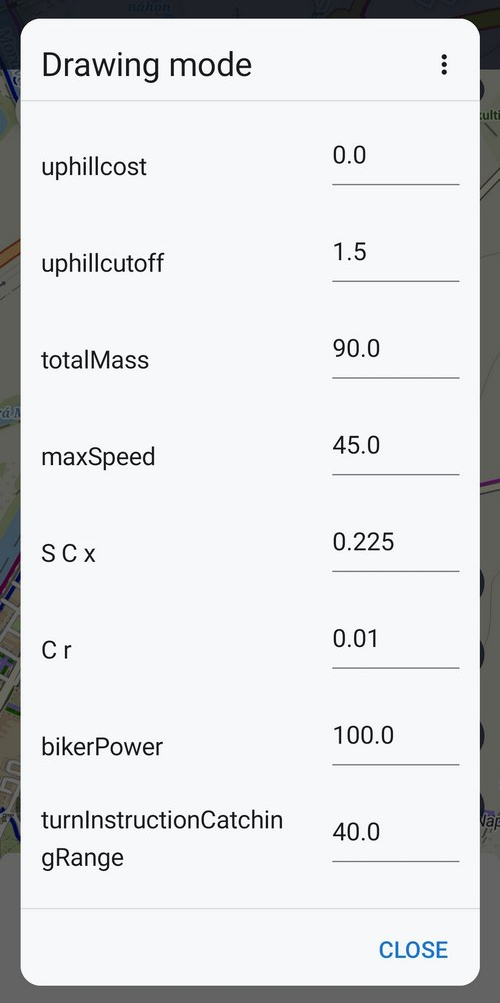
Finally, something for geeks
It wouldn’t be Locus Map if we didn’t have something in reserve for the enjoyment of tech-savvy users. As you know, Locus Map can work with the BRouter offline router. This can be set up as an alternative to our LoRouter if you want to use your own routing profiles. We have now made it possible to set all supported parameters of these custom profiles in Locus Map. But how to work with them and how to get them into Locus is for another blog post, so another time.
Enjoy the summer!
Header photo by Nathan Anderson on Unsplash
androidcommentslab cachesLoCoinslopointsnew releasephotosratingreviewrewardroute planningSharetrack recording
36 Comments
Great update with earning LoPoints. Always wanted this but was afraid to ask😉
Next time, don't be afraid. We are always listening :)
Hi, would it be possible to add in the photo export the meters of altitude?
Hi, we'll wait for more feedback. Until further decision, use the "Track overview" option with detailed stats.
Confirmed, the elevation gain will be added in the next app version.
Hey, we need a map switch button on the main screeen which we can switch between setallite map and lomaps or other maps. And if you determine a key shurtcut for this button, we can control with one button which is connected with bluetooth hardware contreller during activity.
That can be done with tasker....I swop maps back and forth by shaking phone
Go to the menu > all features > various > floating menu. It's designed for BT controllers' joysticks and each button in the menu can be changed - I recommend adding "quick map switch".
Good work, as always!
Thanks Ralph!
It's nice to receive LoCoin for a picture. But this also leads to some people posting pictures that have nothing to do with the object. Komoot has the same problem with the highlights.
Possible solution:
You can also report pictures and they may be removed. In this case, the points should be deducted again. Ideally, the user should receive a message each time. “Your picture has been reported and the LoCoin has been deducted.” The message would be important: 1. so that he knows so that there is no point in posting false pictures. 2. the many messages will then annoy him.
Translated with DeepL.com (free version)
Is this also available für locus classic?
This option is only available in Locus Map 4.
Completely agree....very important
Completely agree....very important
Hi Freischneider, each photo added to a LoPoint is manually checked by a team member and approved or disapproved. LoCoins are only added for approved photos. If an unacceptable photo accidentally goes through, other users can report it and we will remove it. After three reports the user is completely banned without further possibility to add photos.
That is of course even better. But it's a lot of work for you.
Totally agree to avoid fishing for LoCoins only without important input and spammers - like at Komoot
Hi, each photo added to a LoPoint is manually checked by a team member and approved or disapproved. LoCoins are only added for approved photos. If an unacceptable photo accidentally goes through, other users can report it and we will remove it. After three reports the user is completely banned without further possibility to add photos.
Great job! Very big thanks for ongoing improvements!!
A 'wish' for your feature list would be a Warning ⚠️ message, if Power Saving mode is active while starting track recording. Best with a deep link to the phones settings menu for a quick deactivation. I'm often forgetting this 🙈.
(Stadtradeln app let me love such function on my Samsung galaxy during this year competition weeks to get a proper tracking)
Hi Fabi,
such a warning with a link is displayed on the track recording panel before you start recording.
Still like the idea to provide photos and also ratings to OSM Points, but what would be very important for me, and also an absolute prerequisite for me to contribute to it, would be that the photos and ratings are licensed under an open license, just like the OSM data itself is, and accessible via a documented API that allows them to be used in other apps.
Otherwise I see no point in building the 100th closed collection of photos/ratings of points of interests, there are already plenty (Google, Komoot, Tripadvisor, Foursquare, OpenTable, yelp...) why building yet another one when the data is not open?
Locus benefits strongly from the OSM project and this would maybe be a great way to enrich the OSM ecosystem.
Hi, this is kind of an egg & chicken problem :-) . Your suggestion has been in our considerations for a long time, but there are several reasons that prevent us from already communicate it as open data like that.
There is currently no easy way to merge such data directly into the OSM dataset so that others can easily benefit from it. But in order to begin efforts to make the data available in some form outside of our applications, we first want to know at what rate we can collect such data through our application and our community. Then there are legal obligations to you, the users. We are still in the early stages of building such community content, so we do not yet feel comfortable focusing our energy on making it available to others, as this would be much more complex project than the functionality we currently have.
I understand your point of view and thank you for your feedback. But I don't think that making data open will dramatically change the motivation of users to participate now. So this is a topic for us to revisit in the future.
Great improvements for using BRouter!
Thanks a lot, looking forward to the next blog post for details on Locus setup with BRouter (somehow I manged integration but still looking forward to the "official" way of doing).
Hallo,
zur Marschzeitberechnung gibt es eine DIN-Norm 33446. In Wikipedia ist dies so beschrieben:
"2004 wurden diese Erfahrungswerte in die DIN 33466 Wegweiser für Wanderwege aufgenommen, welche auch in den anderen deutschsprachigen Alpenländern und in Slowenien zugrunde gelegt wird. Dabei gilt als Bemessungsgrundlage:
Ein Wanderer legt in einer Stunde zurück:
300 Höhenmeter im Aufstieg
500 Höhenmeter im Abstieg
4 km Horizontalentfernung.
Die nominelle Gehzeit einer Strecke wird errechnet, indem von den für Horizontal- und Vertikalentfernung errechneten Zeiten der kleinere Wert halbiert und zum größeren addiert wird."
Es werden also 3 - benutzerdefinierbare -Parameter benötigt:
- Höhenmeter pro Stunde im Aufstieg
- Höhenmeter pro Stunde im Abstieg
- Horizontalentfernung pro Stunde
Können Sie bitte dies in Locus Map einbauen?
Ich hatte dies bereits vor Jahren angeregt.
Danke und Grüße
Werner
Hi Werner,
currently, for walking and hiking activities, previous (I believe de-facto) standard is used - Tobler's formula. Yes, DIN 3346 is definitely a consideration. But there is one additional aspect, quite important in the context of hiking: For ETA, not only flat speed, ascent/h, descent/h are important. Also the surface and trail type, trail visibility e.t.c. Locus takes into consideration all of that - rocky, narrow, yet flat trail is not the same as some paved footpath by river, even though from the viewpoint of all common ETA calculation methods these are the same. And there is room for great improvement, as there is no statistical data. Radim, Locus team.
Thx for this releases. Hopefully the share feature helps to make LocusMap more popular!
Unfortunately a lot of my outdoor friends never heard of your great app...
Hi Christof,
we are hoping too :) More users means more revenue which can be re-invested to the development and new features and services.
Salve, grazie per questa nuova funzionalità. Ho già iniziato a inviare le foto dei posti dove sono stato (Italia-Basilicata-Massiccio del pollino) e alcune sono già state approvate.
Inoltre ho appena disdetto l'abbonamento a wikiloc che al contrario ha appena comunicato che aumenterà il prezzo del 50% !
Praticamente devo pagare per pubblicare le mie foto !
Sarebbe bello se locus riuscisse in futuro anche a riunire le tracce gpx di noi utenti
Magari cliccando su una vetta , potrebbero uscire i vari percorsi disponibili (anche questi votati da noi utenti)
team amici montanari Puglia e Dintorni
Hi Giuseppe, firstly, thanks a lot for your photos, they're amazing. As for the tracks from other people, the base has been laid - it is possible to share tracks via links. The second step, so that the tracks are visible as a layer on the map, is awaiting implementation. We are sorry that all changes and improvements are emerging slowly but we work in a very small team with a budget dependent on the number of users willing to activate Premium plans.
We want integration with Bosch kiox.
Thanks you.
Hi, we want it too but Bosch does not :(
Hello,
maybe I didn't find it but is there a way to create LoPoint (also adding it to OSM) and add photo to it. Lately I have found multiples of shelters which are not yet in map and so far my solution for this is take photo/point with photo as note in Locus to create OSM points later. The later part takes additional time which I usually don't get to, so my backlog of these points growing.
Hi,
unfortunately, this feature is not available at the moment. Actually, we've been discussing it for some time so maybe, in the future... For the time being, please use another app for editing OSM directly, Locus Map only offers OSM Notes for notifying the OSM community about the map error.
hello
Hope ios version can update Chinese.
thanks you
Hi, all our apps and services are translated in a open crowdsourcing project based on the Crowdin platform. If you are willing to participate, we'll heartily welcome you: https://crowdin.com/project/locus-map-ios/invite?h=77aa40e571900f6c832af6d77d62f62d2153737.