Locus Map 4 is so different from Locus Map 3 Classic that there is no need to deal with their differences too much. These are clear – the “4” has a much more ergonomic user interface, it can synchronize data with the cloud, communicate with a web-based route planner, it has its own offline router… Yes, but some of these benefits can only be found in the highest Premium Gold subscription.
But still, we have Premium Silver here. “It’s the same as the Classic version so what’s all that hassle about?” many say. So how can you decide what to do? Should you go for a prepaid Silver, or stay with the well-proven Classic (ex-Pro)?
The FAQ section of our website offers a brief answer. However, many probably overlook it or do not find enough detailed information in it, as we are still getting questions about version differences. That is why we’re bringing you a more detailed summary here in the blog, which will be pointed out by notifications directly in the application:
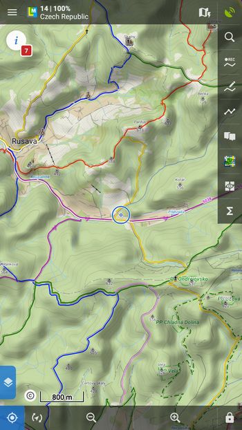
Main screen and menu
Locus Map 3 Classic
It is based on years of organic development of the application according to current trends, but mainly according to the wishes of users concentrated mainly in the community on the Locus forum. Admittedly, it’s not very intuitive or ergonomic, features and buttons were added gradually, and with the growing amount of what Locus can do, the UI became increasingly confusing. Unfortunately, this discouraged new users in particular. Nevertheless, this version of the interface has its rock fans, which is why we keep it in Locus Map Classic.
Locus Map 4
We’ve been looking at its UI more in terms of clarity and ergonomics:
- all important controls are at the bottom of the screen for easy thumb control. Only the information bar remains at the top (hidden by default)
- all buttons and panels can be hidden individually
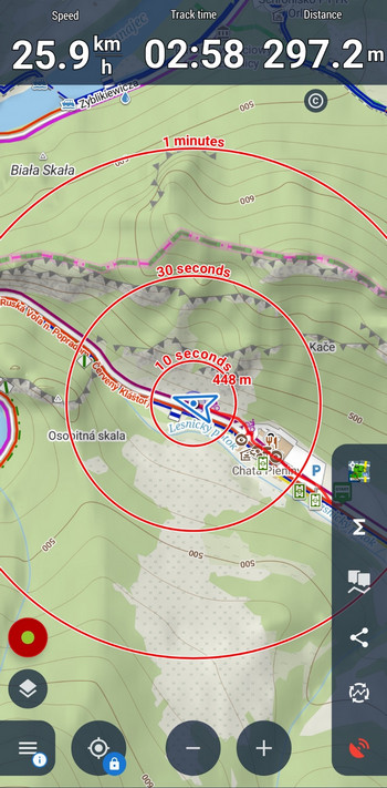
- there’s an option to flip everything sideways for left-handers
- and also the dark mode saves the battery
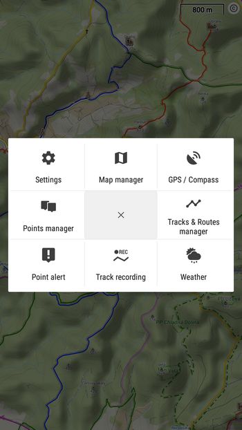
- the 8 core features are in the first level of the main menu, and the number of buttons can be expanded almost twice. All buttons are customizable.
- all functions of the application are then clearly sorted by categories and can be searched for in full text
- we’ve retained the popular fully configurable sidebars
- we have added a special floating menu for external Bluetooth controllers
Panel with the route or point details
Locus Map 3 Classic
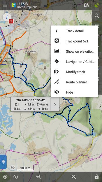
In the original version, you can access the details of the route/point via an intermediate step – a popup box on the map. This popup contains basic information and has its own action menu, configurable in the application settings. The details then expand to a full screen with several tabs. For many, the solution is complicated, but “hardcore” users praise it.
Locus Map 4
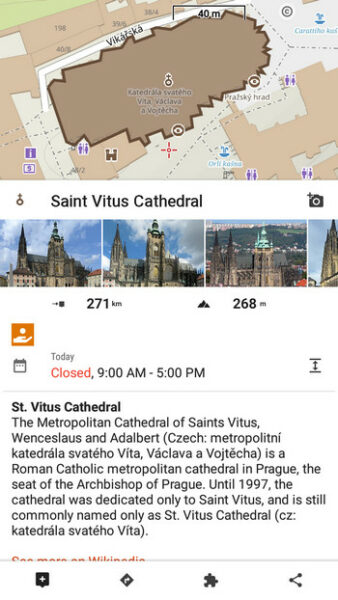
The new solution is much more compact. In the case of a route, a panel with basic information, an elevation profile with a trackpoint position, and a toolbar open on the first click.
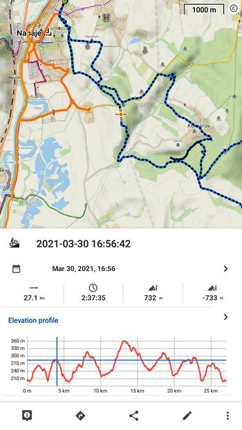
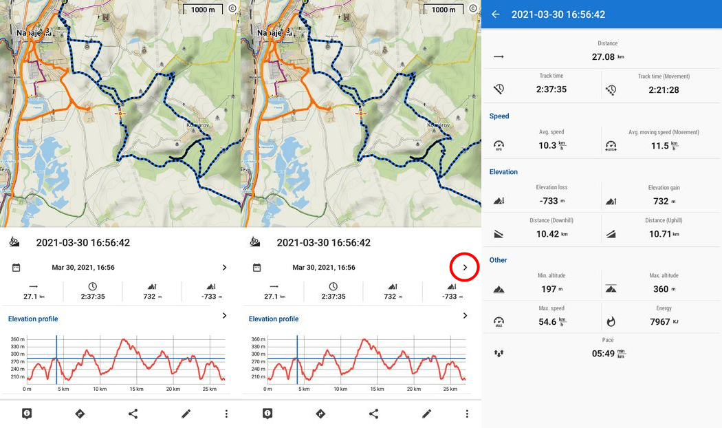
Each category of information has its own maximize button, which expands it to full screen:
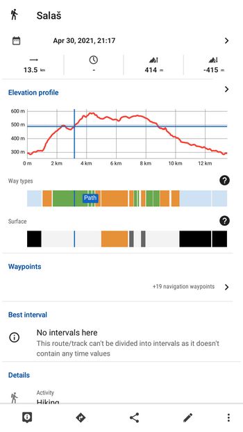
Further sliding the panel up shows more information – types of paths and surfaces, waypoints, classification into folders…
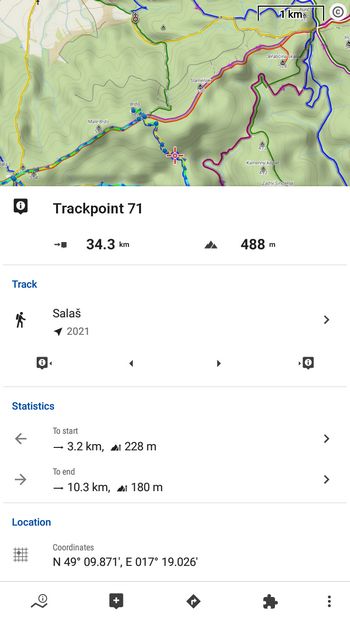
The button at the bottom left opens a separate panel with information about the selected trackpoint:
Similarly, for the point details, we chose a compact solution with a sliding panel. In the case of geocaches, on the first click, in addition to basic information, the number of trackables and waypoints also appears, which you can maximize into further detail. And also a toolbar with buttons, three of which you can reset to suit your needs – put a login button, hint, etc.:
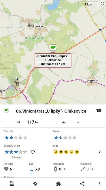
By further extending the panel, the app displays the attributes of the cache, the beginning of the listing, and other parameters. A menu with specific geocaching tools is also at hand.
Online maps, points of interest, and router
Locus Map 3 Classic
The application relies solely on third-party resources for online maps, points of interest, and routers.
- one of the publicly available OSM resources is displayed as the default map when the application is started for the first time
- dynamic online points of interest are not on the maps
- only GraphHopper is used as an online routing service
Locus Map 4
We have equipped the new generation of the application with a complete package of our own free online content, which is also available in the basic non-prepaid version of Locus Map 4:
- LoMap Online – a tuned optimized map of the world in a hike/bike theme with marked hiking and biking trails. A winter version with ski pistes and trails is available too. Maps are updated every 24 hours. Of course, other online maps remain available.
- LoPoints online – places, areas and objects on the map with Wikipedia descriptions and photos, added user photos and much other information like opening hours of restaurants and shops, links or contact info. LoPoints are fully searchable.
- LoRouter online – a powerful router for fast route generation when planning or navigating to a destination. It contains the same routing profiles as our web-based route planner, from where you can export routes for use in Locus. However, you can also use the aforementioned third-party routers if you like them.
- Global satellite map – available in Premium Gold tier, rendered from Maxar and HereMaps aerial and satellite photo data
The integration of our online content services has been quite a challenge for us, but in addition to the benefits they already bring, they give us a wide range of opportunities to further supplement and improve the content in the future. And be sure – we have big plans. We believe you have something to look forward to!
Other differences in details
- directly in the route planner in Locus Map 4, you can open the content panel and easily change the background map, display or hide points of interest, active items, etc.
- Locus Map 4 supports also OneDrive for backup or direct import/export of routes and points
- support for WMTS resources – the long-awaited modification allows you to use a lot of other high-quality map data
- new sensor manager – we have merged Bluetooth and ANT managers into one center, which manages connected accessories – sensors, external GPS antennas, etc. Support for power meters and Specialized e-bikes is included.
- plus hundreds of other minor changes, such as search in settings
What else do we plan to do?
Although we continue to maintain and update Locus Map 3 Classic to make it fully usable on new Androids, Locus Map 4 is the foundation of our future plans. With this in mind, all its parts have been developed – whether we mean UI, content services integration, or a more sustainable financing model. If you decide to activate one of our Premium tiers in Locus Map 4 instead of purchasing the Classic version, not only will you receive more new features in the future, but you will also allow us to implement new features and integrations into other services faster.
We leave it up to you to decide whether to install Locus Map 4 Premium Silver or stay with the good old Locus Map 3 Classic. We provide the care that belongs to both products. And if you’ve already purchased the Classic or former Pro version and want to switch to Locus Map 4 sometime, you’ll get a discount that offsets the original purchase. So you don’t have to worry more about the first choice.
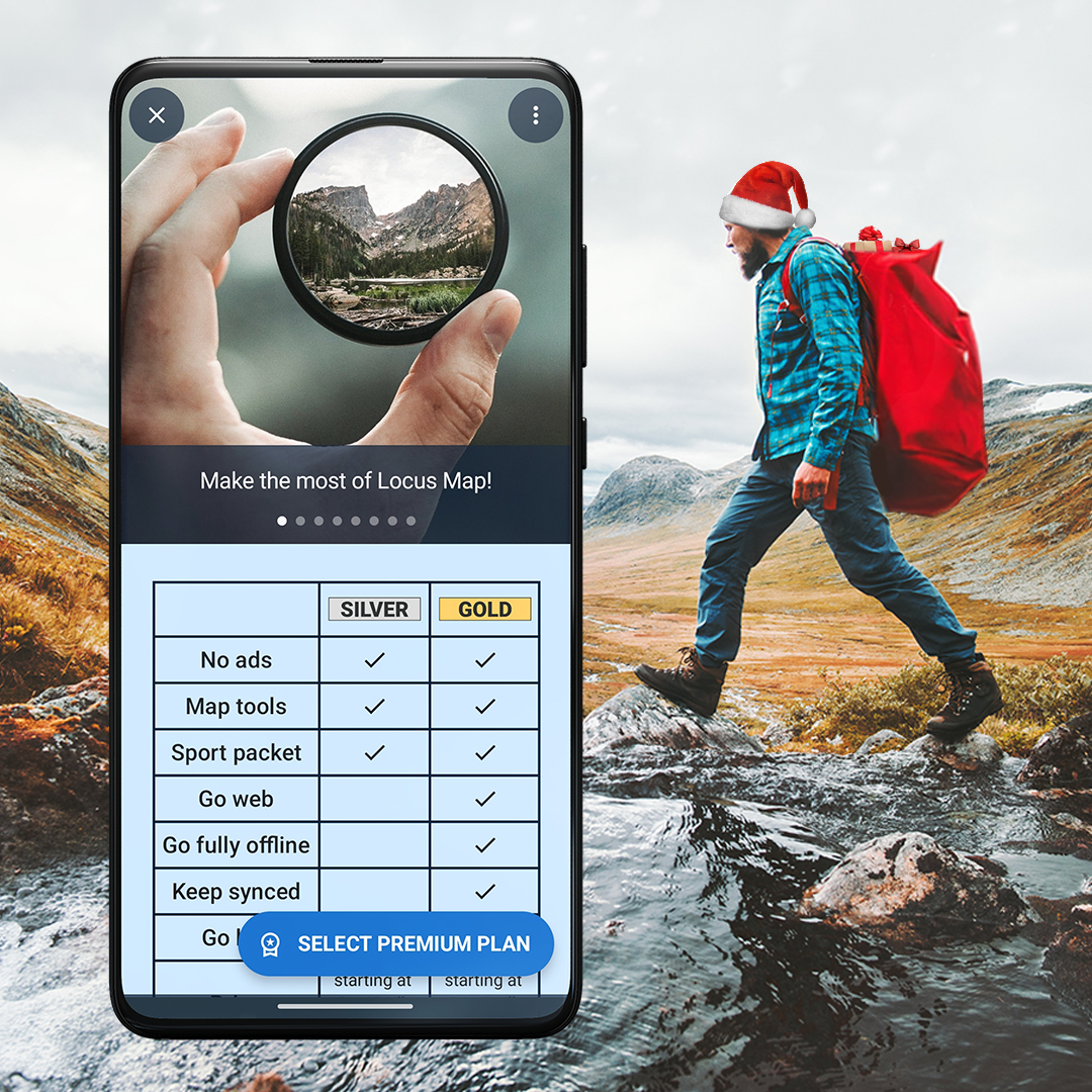
differencesLocus Map ProLoMaps onlineLoPoints onlineLoRouterPremium Silver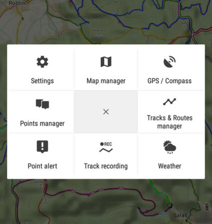


57 Comments
Wann werden Smartwatches in 4 unterstützt?
Hi Olaf, they are supported. Install Locus Map Watch for Wear OS or Locus Map Watch Free for Samsung, depending on your watch.
Hi,
wie aktiviere ich denn die Anzeige der "Way Types" bzw. der "Surface" unter dem Höhenprofil?
Hi, way types and surfaces appear only when you use LoRouter (online or offline) during the route planning.
Hi. I'm silver user and I do not have surface and way types even if I plan my route in Locus app.
Also can I change the colour of the "clicked" track on map from white to other colour?
Hi, surfaces and way types are available in Premium Gold subscription.
What about the second question?
When I click on route its white with black arrows. Can I change these colours? Its not readable for me especially when I ride a bike.
You can change the route colors in many ways and levels: https://docs.locusmap.app/doku.php?id=manual:user_guide:tracks:management#track_route_style
Hallo, super Entwicklung! Wann wird es möglich sein, seine Routen (auch gerne inkl. POIs und Fotos) in der Community zu teilen? Ähnlich wie komoot? So dass man Touren und Tipps (von anderen) in einer Region suchen kann?
Lg Dirk
User points should be available within this summer, attached media will take a bit more time to implement. Community sharing is planned in the future.
Great to hear that! Thanks, i like it! :)
Greets Dirk
Dobrý deň, mapy shocart sú vo locuse 4 naďalej spoplatnené? Ďakujem
Dobrý den, ano. SHOCart mapy prodává prostřednictvím Locus obchodu společnost Freytag-Berndt.
Dobrý den,
v popisu Locus Map 4 uvádíte, cituji "Dokonce pro vás vymyslí okružní trasu nebo více tras do stejného cíle." Okružní trasy mi fungují, ale nemůžu nikde najít více tras do stejného cíle. Jak a kde to zapnu nebo nastavím?
Mám předplatné Gold.
Předem děkuji.
Dobrý den, tuto funkci Locus umí pouze ve spolupráci s routerem GraphHopper. Nastavte si jej v nastavení > navigace > router. Nemusíte nic extra přepínat, při plánování bude router rovnou nabízet dvě různé trasy
Aha, děkuji za informaci.
When I click on a trail, I want to see the distance of the point from start and finish. This used to appear immediately but now is fiddly to find. Annoying on a regular basis.
On the planner tool, why is it not possible to change the Map ?
I need more precise topo map, for example for Switzerland and France
Hi Philippe, in version 4 it is possible to change map layers in the route planner.
Když kliknu ve FAQ na "Přehled rozdílů mezi Locus Map Pro a Free" vyskočí chyba 404.
Díky, opraveno
Locus Pro funktioniert ohne Google-Dienste, Locus 4 nicht, zumindest nicht silver oder gold, man kann nicht bezahlen! Ist da noch was geplant? Ich würde gerne wechseln!
Hi, neither Locus Map Pro works without Google PLay services - as it is distributed only via Google Play, its license can't be verified otherwise. We are developing our own distribution platform but it is still a long way ahead...
Locus Pro does work without Google Play services! I purchased via Amazon!
Da Amazon keine Updates mehr anbietet, wurde es entfernt.
I look forward to this. I am happy to pay for this amazing app. However I am unwilling to work with Google Play Services. They are an evil monoply and are grubby data thieves.
Hallo, wird es irgendwann auch bei Locus 4 die Möglichkeit einer Einmalzahlung geben?
Hi Ralph, Locus Map 4 will always be free or with subscription.
I ride a bike 5 months a year, why do you want me to pay for the whole year?
Hi, we don't want you to pay anything. You can use the app for free :) Or, if you want more, you can subscribe monthly and unsubscribe after 5 months.
Unfortunately, the only way to pay for premiums is through google pay :(
An attractive app but unfortunately without other payment options
Ukazuje len rovnu ciaru a menej km ako prejdem v terene
Dobrý den, vyjměte Locus Map z optimalizace baterie a povolte mu přístup k poloze při běhu na pozadí. Více info viz https://docs.locusmap.app/cs/doku.php?id=manual:faq:gps_lost_fix_android6
Werden die Wegbeschaffenheiten nicht angezeigt, wenn die Route mit dem Webplanner gemacht wurde?
Ich habe übrigens die Locus 4 Gold Version
Hi Martin, what exactly do you mean by the route conditions? The route is displayed the same way in the app as it was created in the web planner.
Ich meine "way types" und "surface", die unter dem "elevation profile" zu sehen sind.
Bei mir sind diese leider nicht vorhanden.
am besten im Helpdesk melden. Eventuell ein Bug oder Bedienerfehler.
https://help.locusmap.eu/
Budu Locus mapy dostupne aj v hodinkach Samsung Galaxy Watch 5 Pro? Zatial som nenasiel moznost ako ich tam nainstalovat.
Dobrý den, ano, aplikace je nyní v procesu schvalování na Google.
Ich meine "way types" und "surface", die unter dem "elevation profile" zu sehen sind.
Bei mir sind diese leider nicht vorhanden.
These can only be displayed if the route was created in the route planner.
Ist mit "route planner" nur auf Android gemeint?
Oder ist mit "route planner" auch der webplanner gemeint?
What I don't understand is why linking maps in external directory has been disabled in the Classic version while it still works for the Silver? The excuse in the past was the changes made to the Android OS, but this sounds more like a force upgrade if we want to retain that feature. If it can be done in the Silver version, it should be put back in the Classic version since that feature existed when I paid for it. Thanks.
The file management is the same for both apps. If you have any problem, please contact our support at help.locusmap.eu and describe the issue in detail, send screenshots, etc.
Přišla mi aktualizace na 3.63 a najednou aplikace není ve full screen nejde mi to nastavit zpět. Rozbíjení trojkové placené verze abyste donutili uživatele na předplatné čtyřky už je docela otravné.
Dobrý den, fullscreen jsme byli bohužel donuceni odstranit kvůli četným problémům u různých zařízení, a to z OBOU VERZÍ - z LM3 i LM4. Problém způsobovaly zařízení s notchi, bulletholy, s výsuvnými systémovými SW tlačítky apod, bohužel varieta nadstaveb u Androidů neumožňuje jedno robustní řešení fulscreenu. Mapa je nyní vidět pod průsvitnými lištami.
Ich denke damit es mit dem Webplaner auch geht.
It is possible to view the photos on the web planner but not add them - this is possible only via the app.
kann man Locus classic und Locus map paralell installieren
Yes, that's possible. Both are independent apps.
Danke, habe die Locus 4 Premium gold paralell zur Classic Version installiert, teste einmal für ein Jahr
I reinstalled locus map pro because after not using it for some time, it didnt show the track when recording, only the start and the end. Now i have locus 4 and it s the same. Why it doesnt show the whole track? I use it for hiking.
Hi, please get Locus Map permission for all-time access to the location and exclude Locus from all means of battery optimization so that the app can run in the background, see http://docs.locusmap.eu/doku.php?id=manual:faq:gps_lost_fix_android6. Also, switch ON Google Services assisted location in Locus settings - GPS&sensors.
Ja to vidim tak, Locus map Pro bola platena verzia Locus map. Akurat raz zaplatim a mam. Kedze uz vsetci mali Pro, bolo treba obnovit zisky. Urobila sa "nova" aplikacia (locus map 4) a tam si zas mozes zaplatit za silver alebo gold edíciu. Za mna cisto kšeft. Co branilo upgradovat Locus map Pro? Tuzba po zisku.
Samozřejmě, jako každá jiná firma potřebujeme zisky, abychom mohli fungovat. Naši uživatelé chtěli služby, které potřebují kontinuální financování - webový plánovač, routery, cloudové služby, předpověď počasí atd. K tomu samozřejmě kontinuální vývoj nových verzí, údržba, podpora, propagace... Tohle vše bohužel nelze ufinancovat z jednorázových prodejů.
Dokud budete micro keši říkat XS (je to vlastně tak?), tak zůstávám u Locus Classic...
Uvedené označení velikosti XS až XL šetří místem a je pro každého pochopitelné (až na výjimky ;)). Takže o změně neuvažujeme. Nicméně Locus Map Classic i nadále udržujeme.