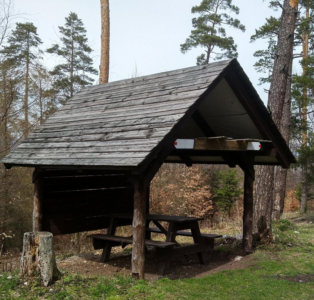
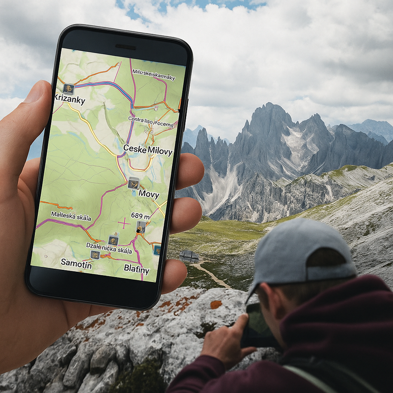
The day’s hike is going great, you still have 10 kilometers to go, and the sun is shining, but so what? There’s a rumble of thunder, a blackened wall looming over the horizon. An ominous spot with a purple center grows on the radar right in front of you, heading in your direction—a storm like a hell. You’ve got to take cover somewhere. There’s a shelter on the Locus Map just a kilometer down the road from here. But can you fit your whole party in there? You wish you had a photo of it…
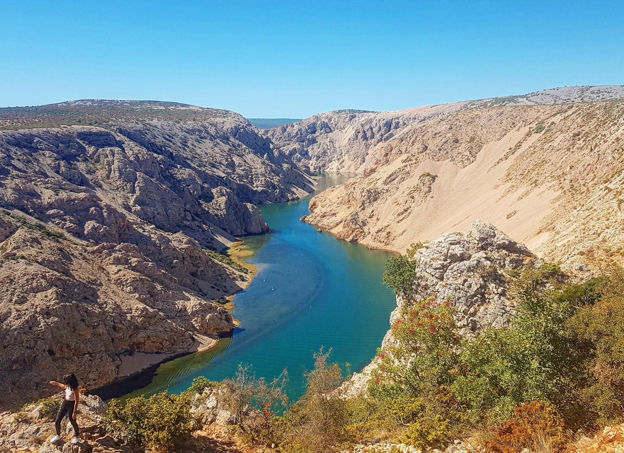
You’ve come on holiday and are planning a trip around the area with your friends. There are several attractions on the map that encourage you to visit. Some rocks, a ruin, a view… But is it really worth including them in the itinerary? What do they really look like?
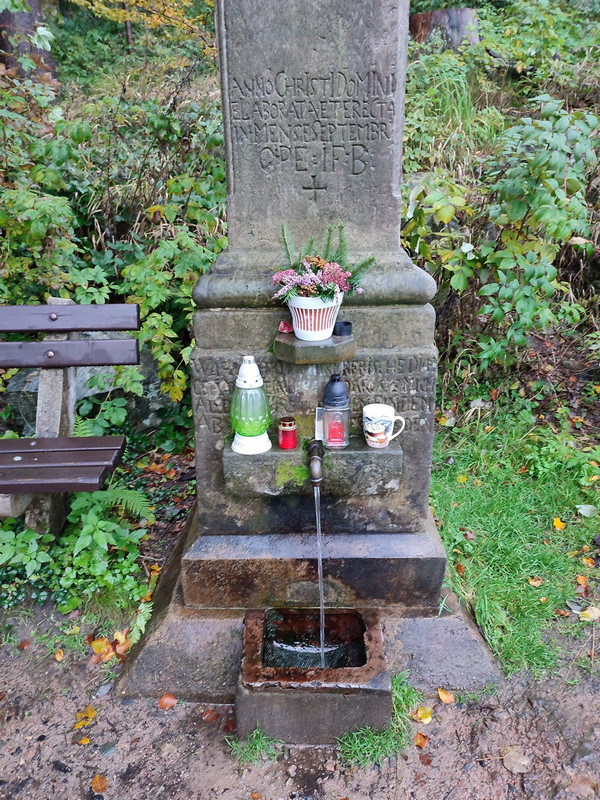
It’s terribly hot, you underestimated it on the hike with your water supply. The nearest pub is on the trail, but only in about an hour. You check the map, and look, there’s a spring just down the road. Is it just a spring seeping out of the swamp, or is it covered, with a trough, and can you conveniently refill from it?
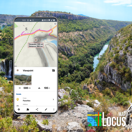
We’re sure you’ve experienced similar situations on your wanderings through nature. “If only I had a photo of that…, to know what it looks like…” – these and similar questions from our users inspired us to create the possibility to add our own photos to places on the map (so-called LoPoints). Having them available both on your mobile phone for a quick preview and above the map on the web for careful route planning is something that many outdoor enthusiasts will appreciate. No text can describe reality as well as a picture.
A lot of LoPoints already have photos from Wikipedia. However, Wikipedia does not contain every shelter or view tower, photos are usually only provided with the biggest attractions – tourist, historical and natural attractions – castles, chateaus, museums… Pubs, ruins, signposts, stops, shelters, wells… are still without photos. And now we want to help you change that.
Photos directly from your mobile
Adding a photo to a place of interest on the map is quick and easy:
- tap LoPoint on the map, and a panel with details will pop up
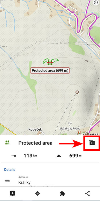
- tap the camera button
- select the option to either take the photo now or select a photo from the gallery that is already taken
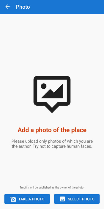
- after confirming the photo or gallery selection you can add more snaps if you have them
- close the window, and the photos will start uploading in the background and you can continue to use the app normally
Not on the internet? No problem, everything works offline too. Photos will upload when you connect. By default, uploading is only enabled via wifi, but if you’re not worried about your mobile data, turn wifi-only off in the app settings.
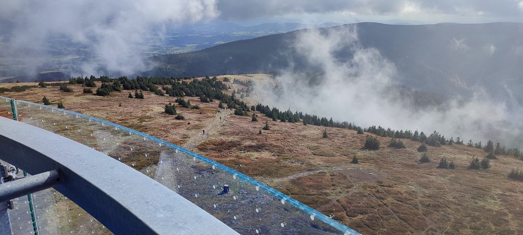
Which photos are the best?
Those that accurately depict the object or place in question. Best if you take several photos of the same place from different angles. And now some tips:
- If it’s a view tower or a lookout point, include a view of the countryside from there.
- For more complex buildings or monuments, include the most interesting details
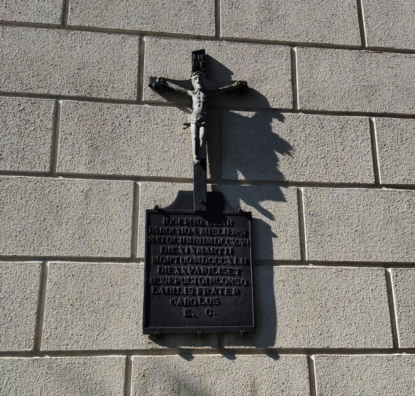
- Photograph information boards preferably in such a way that the text on them is legible in the photo – both in the app and on the website, the photo can be clicked through to the detail
- For restaurants, you can take a photo of the menu if it is legible
You can “like” each photo in the app and on the website.
Which photos are inappropriate?
Each photo is checked before it is attached to a place on the map. Images that in any way fit into the following categories will not be added to the locations:
- showing recognizable human faces
- depicting violence, racism, politics, memes, profanity or other obscenities
- photos of poor technical quality – blurry, too low resolution, too dark, too light…
- graphically modified photos – tilted photos, with labels, texts, frames, and other decorations
- images unrelated to the location or otherwise irrelevant
You will receive info about the acceptance or non-acceptance of photos within a few hours.
If by chance an inappropriate photo slips through our careful filter, or for some other reason you find it unacceptable, you can report it to us:
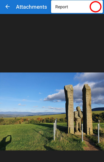
We will check it again and possibly eliminate it.
What about privacy?
Adding photos to places on the map is seen as a voluntary service to the public. By submitting a photo, you agree that the image will be published on the map via Locus Map with the author’s credit. We therefore strongly recommend that you only submit photos that are not in any way private, showing for example members of your family or your home.
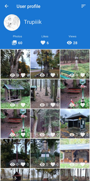
In addition to the map, photos are also displayed in the public photo gallery that is part of your user profile. This is currently only accessible from the Locus Map application:
We also reserve the right to publish selected photos on our website or social media to promote the app or user competitions.

29 Comments
Super orodje👍
Geht das nur locusmap4 oder auch classic?
Nur Locus Map 4.
Kein Interesse. Wieso nicht gleich ein Video von jeder Strecke mit Helmkamera. Dann kann ich vorm Wandern schon mal zu Hause alles sehen und gleich da bleiben. Selten dämliche Idee.
Du muss es dir ja nicht anschauen 🙄
Selten dämliche Antwort gelesen
Genau du musst dir das nicht anschauen a, finde es ist eine tolle Idee
Als Fernwanderer weiß ich Fotos von Schutzhütten und Wasserquellen sehr zu schätzen und bin dankbar für diese Möglichkeit!
Sry, aber das widerspricht für mich der Idee des Wanderns komplett. Man erwandert etwas, man entdeckt, man sieht auch mal, dass etwas nicht so schön ist wie gedacht und das ist gut so, schafft erst Wert.
Die Gleichen, die jetzt sagen ,,musst es dir ja nicht ansehen" sind gewöhnlich die, die später sagen werden ,,wieso hast es dir nicht vorher angeschaut, steht alles im Netz".
Ein Folgeproblem ist nämlich, dass es Standard und damit erwartet wird.
Ich will wenigstens beim Wandern etwas Abenteuer und nicht alles 110%ig abgesichert.
Ich mag damit allein da stehen, was ich nicht erwartet hätte, zumal Gespräche mit anderen Wanderern eine ähnliche Sicht erwarten ließen. Das, dass anscheinend doch nicht so ist, ist enttäuschend. Man unterscheidet sich da wohl doch sehr.
Und letztlich ist das nur der Anfang, früher oder später ist jeder "Pfurz" fotografiert und integriert, meist dazu in miserabler Qualität.
Beim Wandern stimme ich zu. Irgendwie kann der Reiz des "Abenteuers" verloren gehen. Andererseits nutze ich als Vorbereitung auf eine(n) Urlaub(sfahrt) doch gerne alle Google Infos inkl. Rezensionen und Fotos.
Wer ein "Abenteuer" sucht, sollte vielleicht gleich einfach nur "drauf los wandern" - ohne Navigation! So wie früher - nur mit Papierkarte und Kompass!
Alle Anderen werden sich über Bilder der Orte die man als Ziel auswählt sicher freuen....
Všimli jste si, že existují mapy od Google, kde jsou fotky prakticky k čemukoli? 😉
Ale teď vážně: Google má tohle funkci zpracovanou daleko líp, protože se čas od času zeptá, jestli chcete zveřejnit svoje fotky míst, která jste navštívili, včetně případného hodnocení. Je to daleko jednodušší, proto jsou tam taky fotek spousty.
Souhlasím že funkce, která mi navrhne které fotky by se mohly hodit k danému bodu, by byla fajn. Hlavně k doplnění z existujících starých fotek. Bych mohl využít k zabíjení času v MHD, čekání na jídlo v restauraci .... .
Takové přístřešky si pro budoucí referenci fotím už nějakou dobu. Obdobně třeba i některé zastávky ....
Teď mě například napadá jeden krásný přístřešek, který si upload foto zaslouží. V mapě se mi ho asi podaří najít podle záznamu aktivity, ale dohledat fotku bude celkem práce. Co jsem rychle proklikal, tak používáte systémový dialog výběru foto z úložiště. Nějaká šance výběru, který mi nabídne blízké foto podle lokace alá Strava "taken during activity"?
Díky
Michal
Zdravíme Michale, ano, tohle je jistě dobrý nápad, uvidíme, co se s tím bude dále dát udělat.
Dobrý den Václave, a všiml jste si, že Google aktivně sleduje pohyb lidí aniž by měli zrovna Google Maps aktivně puštěné? Locus Map jede čistě na aktivní bázi. No a Google tohle dělá řadu let u miliard lidí, zatímco my ani ne rok, s dosahem pár tisíc lidí... Ale děkujeme za radu ;)
Paráda!
Ganz nett, aber ich habe nur Interesse dran, wenn die Fotos in einer offenen Datenbank landen, die sich auch von anderen Anwendungen über eine API nutzen lässt. Etwas wie openplacereviews.org, was leider eine ziemlich Totgeburt war. Solang die Fotos nur von Locus aus nutzbar wären würde ich definitiv nichts beitragen, geschlossene Communities wie Komot gibt's schon zu viele, wenn muss es was Offenes sein.
Wenn ihr hier hingegen was auf die Beine stellen würdet, vielleicht sogar mit Reviews der Orte wäre ich sofort dabei, das suche ich schon seit langer Zeit.
Hi Patrick, the project is still at its beginning. When there is some reasonable amount of data in it we will consider opening it for other applications.
▶️ Regarding license, i strongly advise anybody to support only free/libre databases, like Wikipedia or OpenStreetMap, which are under a CreativeCommons license.◀️
Don't put your work and effort into a proprietary app, neither in Google nor something else. Others won't be able to share, adapt or remix your work. If the company closures, all your work is lost.
@Michal: It is not feasible to change the license of a database, so do it right the first time.
Fotos von Infotafeln? Springbrunnen? Steinsäulen? Haha, dann kann man endlich die ganzen Multis zu Hause auf dem Sofa lösen und kann direkt zum Final. Brauch man nicht mehr stundenlang Google nach Fotos quälen. Freu mich schon auf den Aufschrei der Multi und Mystery leger.
Tolle Sache. Und die DSGVO Falle beim veröffentlichen der Bilder lauert ganz nebenbei, ist doch das Fotografieren so mancher Sehenswürdigkeiten verboten.
Ich habe Tonnen von genau solchen Bildern die ihr sucht und würde diese auch gerne teilen, aber ich verwende ausschließlich die Classic Version und werde definitiv auch kein Abo abschließen. Schade (für euch)
Fact 1): Locus Map 4 can run free with the basic features including attaching photos to LoPoints
Fact 2): the photos serve Locus users, not Locus developers. This is a community project based on voluntary contributions
Ahoj,
pri odfotení čohokoľvek, čo chcem vložiť do Vašej databázy, mi pri odfotení na mieste a pred odoslaním fotky ešte dáva možnosť pridať popisok k fotke. Nie je vždy ale čas robiť popisky na mieste. Ak ale chcem dodatočne, doma po túre, pridať popis k mnou vytvorenej a schválenej fotke, túto možnosť tam nevidím. Dá sa to? Alebo k tomu nepoznám správnu cestu?
A ešte tak na okraj - po pripojení na wifi sa Vám automaticky začnú fotky odosielať,
zároveň však započne aj synchronizácia fotiek do Google Drive. No a tie fotky, ktoré sa odošlú Vám, do G-Driveu nedorazia. Vo fotoaparáte/mobile sú, ale na úložisku nie. Netušíte prečo?
Ďakujem za odpoveď!
Nazdar Marek,
1. Túto funkciu aktuálne v aplikácii nemáme. Na implementáciu by to však nemalo byť zložité, takže možno v blízkej dobe pribudne.
2. Na synchronizáciu fotiek do Google Drive používaš nejakú aplikáciu tretích strán? Alebo myslíš Google Photos?
Vopred ďakujem za odpoveď.
Áno, mal som na mysli Google Photos. Tam si potom robím albumy z výletov, ale tie fotky, ktoré som vyfotil pre Locus (z ponuky Odfotiť / Vybrať fotku - vyberiem Odfotiť), tie sa synchronizáciou do Google Photos nedostanú. V mobile ale stále sú, takže si ich dám do Photos "ručne". Nie som expert v týchto prenosoch dát, takže ani neviem posúdiť, prečo sa to tak deje; či je to v nejakých nastaveniach, neviem...
Čo sa ešte týka toho dodatočného pridávania popiskov k nahraným fotografiám, bolo by to, myslím si, užitočné - napr. studnička, ktorá dnes ešte na fotke tečie, môže byť o rok nadobro suchá, alebo prístrešok ktorý včera stál, môže zajtra spadnúť alebo zhorieť... Dá sa to aktualizovať novou fotografiou alebo - ešte lepšie - dodatočným popisom k fotke.
A ešte jedna vec mi napadla, čo sa týka informovanosti turistov. V lese sa pohybujem veľmi často, najmä vo svojom okolí a viem o studničkách alebo o "picnic table" alebo o výhľadoch, ktoré v mapách zaznamenané nie sú. A o tieto informácie by som sa rád podelil a bolo by fajn, keby o nich vedeli aj iní turisti či čundráci. Bolo by ironické umierať niekde na túre smädom a nevedieť, že možno pár metrov od vás je prameň... Dalo by sa aj takýmto spôsobom pomôcť ostatným? Dať Vám info, že niekde niečo JE, aj keď to v mape NIE JE? A zaznačiť to do mapy.
Tož len taký nápad..
Ďakujem za Vaše odpovede.
Ak v teréne pridáš fotografiu k LoPointu, tá sa uloží do priečinka /Pictures/Locus Map/LoPoints. Ak chceš, aby sa Ti zálohovali fotografie aj z tohto priečinka, tak v aplikácii Google Photos klikni vpravo hore do svojho profilu -> Nastavenia aplikácie Fotky -> Zálohovanie -> Zálohovať priečinky zariadenia -> LoPoints. Keď tento priečinok zaškrtneš, zálohovanie by malo začať fungovať.
Aplikácia Locus Map čerpá body z databázy OpenStreetMaps. Ak teda nejaký bod v Locuse chýba, môžeš ho pridať do OpenStreetMaps a po čase sa zobrazí aj v Locuse. Na pridávanie bodov do OpenStreetMaps v teréne je najpoužiteľnejšia aplikácia Osm Go! (https://play.google.com/store/apps/details?id=fr.dogeo.osmgo)
Find ich super, schön wäre nur, wenn man schon in der Karte erkennen könnte welchem Punkt ein Foto hinterlegt ist.
I can't find the "add LOpoint" icon in the available icon option for functional panels.
has this option been disabled?
The only similar icon is named: LoPoint (offline)
Any advice?
Hi Piero,
LoPoints can't be added on the map - they are a part of the OSM database from which LoMaps are generated. You can only add your own points. Use the "New point" button for the function panel.