It’s been over a month since last “big” release and the summer is not only knocking on our (out)door but it’s right here in the middle of Europe with all the sunshine and heat. People gulp gallons of beer and stuff themselves with tons of ice cream and, which matters the most, enjoy trips in the great outdoors. As usual, we’ve got a few more treats for them, for you:
Vacation in Denmark? Why not?
With newly added FREE OFFLINE map combining topographic data of DTK Kortforsyningen and marked hiking and cycling routes from Waymarkedtrails your trip planning in Denmark is a piece of cake! Maps covering European part of Denmark are available in offline packages containing zooms 9-15:
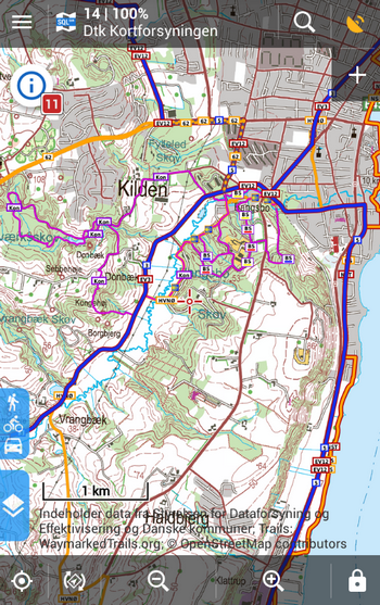
More online free maps in the Store
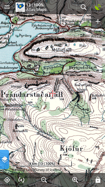
Not only hiking or cycling maps are subject of Locus users’ interest as Locus is not used by pure outdoor freaks only – Locus can serve also as a viewer of topographic or historic maps. From now on you can enjoy browsing historic maps of Iceland, made by the National Meteorological Department of the Danish Army in the first four decades of the 20th century, last updated in 1989. The maps, known as the Atlaskort, are online scanned in the scale of 1:100000 and can be cached.
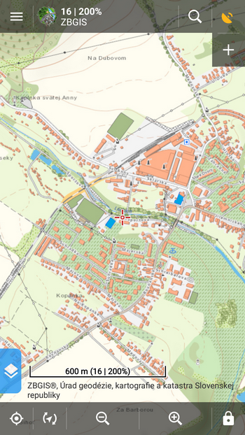
Next we are bringing ZBGIS maps of Slovakia – basic database of Slovak geographic information system for mapping, land registry, cartography and land surveying office. Maps are WMTS based and available in zooms up to 16.
New weather forecast
Planning trips always depends on the expected weather conditions so global localized weather forecast has been always a part of Locus features. Recently we reworked the WF panel and changed the forecast data source. The main page s bigger and clearer:
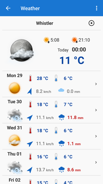
Tapping a day forecast unfolds a new screen with lots of details including meteograph:
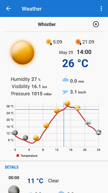
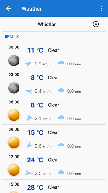
Each day forecast is divided in 3-hours intervals with their own values of temperature, wind speed/direction, precipitation and sky coverage:
Enhanced distance measuring
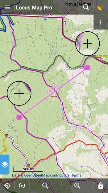
A few months ago we introduced a quick method of distance measuring – by tapping two fingers on the screen. Originally we intended to use this metod just for approximate distance estimate. Many of you liked this method and needed to make it a bit more accurate so we resolved to add magnifiers on both finger points – now you can define the measured points quite precisely:
Custom definition of automatic zooming
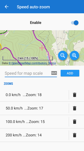
Automatic zooming is very useful when you move at wide range of speeds – typically in a car – and need to have relevant view of the map. When you are traveling fast on a highway you need a low zoom with few details and wider map context. When you are traveling slowly, e.g. in a city center, you need to see as many details as possible – all intersections, traffic lights, oneways etc. All car navigations are equipped with this feature and Locus is not an exception. Although, until now, the speed values per zoom has always had default setting only. Now you can set the speed levels on your own and customize Locus behavior to your needs. The option can be found in Settings > Maps > Advanced features > Speed auto-zoom:
We’ll finish as usual – you know it’s not all the new version introduces. There are many more smaller improvements, UI enhancements, fixes… And one secret at the end (don’t tell anybody ;): it is possible to switch off on-screen blogpost notifications. The switch is somewhere in Settings > Miscellaneous… Enjoy!
automatic zoomingIcelandLocus Map 3.24map of Denmarknew releasequick distance measuringSlovakiaweather forecast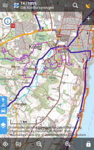


9 Comments
Das "kleine Geheimnis" am Ende Eures Blogpost zeugt davon, dass Ihr von der Qualität Eurer App überzeugt seid, und auch diesen Tipp nicht scheut!
Könnt Igr auch!
Ich werde die Blogposts NICHT ausschalten! Ich mag die unaufdringlichen, unregelmäßigen, vielfältigen Tipps und Berichte zur Nutzung meiner Lieblings-Outdoor-Geocaching-App Locus, und möchte die nicht missen!
Macht weiter so!
Ahoi. Locke.
Hi Locke,
thank you for your kind and supportive words! And yes, we are sure our app is worth the "little secret" :) Enjoy!
Michal
How did you know about my vacation in Denmark?
The new map comes quite handy. THANKS a lot.
Zdravím, ponuku pridania máp ZBGIS som v Locuse 3.24 nenašiel..
(zariadenie xiaomi redmi 3S
Android 6.0.1 MMB29M)
viete mi poradiť pri riešení?
Dobrý den, ZBGIS mapy musíte přidat z Locus Obchodu (Menu > Locus Obchod nebo Menu > Mapy > Online > Přidat další online mapu)
I like to have back the personal setting of zoom levels with autozoom. But i would like to have a grace value for this (either by time or speed) . So if you got stuck around a speed where you would switch zoom level (maybe because of the traffic) the zoom level will constantly flip.
There is not a "grace value" but the speed is filtered (smoothed by software) so you shouldn't jump from one zoom and back when traveling at a constant speed.
Ihr seid ein gutes Team weiter so
Thank you Peter!